I was in Alaska from June 10-17.
This trip was mostly about business with a little bit of pleasure while I was out there. I attended the 2015 meeting of the Animal Behavior Society. This wasn’t my first scientific meeting. But it was my first time at ABS and my first meeting where I was alone. I was the only one there from the University of Idaho, and I didn’t know anyone else there. That made it a daunting challenge to socialize from scratch. But then, the one of the purposes of being there was to meet new people in my field while searching for post-doctoral opportunities. And while I don’t have any definitive leads on post-school employment, I do feel that the mission was a success in terms of getting my name out and meeting others who study animal personalities.
This post won’t be about the conference. Instead, I’ll focus on my Alaskan experience.
Anchorage: June 10-14
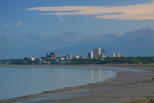
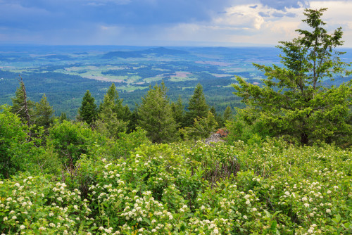
I wasn’t really sure what to expect when landing in Anchorage. I knew that the city was spread out and that the bus system was somewhat sparse. And while I didn’t get to spend much time downtown, I’ve come to the conclusion that Anchorage is not unlike any other small American city. It’s mostly strip malls and housing developments with mostly the same stores, restaurants, and architecture as you’d find back home, wherever home is. Of course there’s always some variation, but for the most part, Anchorage is a new city, developed in the last half century as a destination and port of entry for tourists. Thus if you’re looking for the “real Alasakan” experience, Anchorage is not going to be it. But for all of its generic features, it is still an interesting stop to visit. For one, the city sits at the foot of some rather tall mountains, which gives it a scenic and picturesque setting. And you don’t have to go very far to see wildlife. There are resident urban moose that inhabit all of the city green spaces, and there are a lot of green spaces to visit. The city is quite spread out and public transportation isn’t always the best option. Fortunately, there is an extensive system of bicycle paths that can get you almost anywhere you need to go. It’s one of the more bicycle-friendly places I’ve seen. You can even cycle all the way to Seward along the old Iditarod trail.
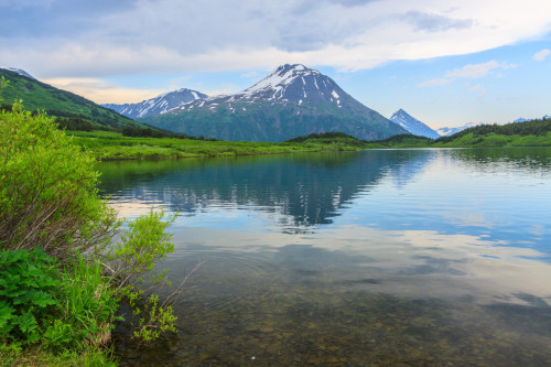
Unfortunately because of the conference, I was not able to really explore the city much. I spent my time out at the University of Alaska at Anchorage, which is on the outskirts of town. There are a few lakes and some trails near campus that I did get to explore. I came across 3 moose – a mom and two calves – just outside of the dorm I was staying in. Of course I saw them when I didn’t have my camera, and didn’t see another moose the rest of the trip. But I did get my moose sighting. After the Conference, I rented a car to drive down to Seward. On my way down, I did get to stop along the coastal trail where I snapped the photo above. All through the conference, we had great weather conditions. It was cool and cloudy the first couple days, and then the sun came out and it was warm. By Monday the 15th, it was almost unbearably warm and humid compared to Idaho. But the biggest disappointment was that I woke up to a very hazy view of the mountains. A large fire had broken out in Denali National Park and the smoke had made its way south to cover most of southeastern Alaska. So much for super clear days, but I made the best of it. It was still clear enough to make out the white peaks of Denali and the Alaska Range from the coastal trail.
Seward and the Kenai Peninsula: June 15-17

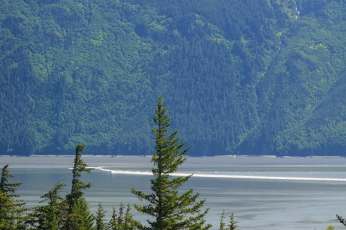
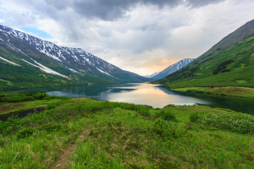
I left Anchorage and headed down for Seward. It’s only a 120 mile drive, but I left myself all day to stop and explore, and I still ran out of time. I thought I’d stop along the way and hike, but instead had too much fun at the many road-side stops along the Cook Inlet (pictured above). One of these stops was Bird Point, a popular place to watch the tidal bore come in. Cook Inlet is the only place to see a tidal bore in the United States and it produces some of the largest bores in the world with waves as high as six feet. The 15th was predicted to be a good day for bore viewing, and while I didn’t get a six-foot wave, it was still quite noticeable.
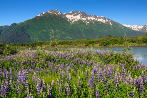
The Bore came in fairly late in the afternoon around 4:20pm. For Alaska, that doesn’t really matter. Sunset in Anchorage this time of year was 11:30, and the night never really gets dark enough to see the stars. As a result, it’s not hard to stay out late and forget to sleep. But the hostel I was staying in required I check in by 10:00 pm, and it was 7:00 by the time I reached Portage at the end of Turnagain Arm. With road construction, I was still about 2 hours away and needed to get into town with enough time to get some dinner. So I reluctantly continued the rest of the drive without any stops. Well, I made one stop. I found a patch of lupines next to one of the river outlets which was irresistible for a photograph.
On Tuesday, I met up with a friend I made at the conference who came down to Seward on the train. I had a car, so we decided to meet up and hike together. We went to the Alaska Sealife Center, a nice little aquarium that focuses on the aquatic life of Alaska. Unlike other large aquariums that showcase fish from across the globe, this one only features native sea life. It’s the only public aquarium in Alaska and the center also contains a research and rehabilitation facility. After touring the aquarium, we headed inland to hike to Crescent Lake. This 7 mile round-trip hike starts off steep, but reaches the valley floor at 1500 feet and levels off for the rest of the duration. Here we pass Carter Lake and view some spectacular scenery on the Kenai Peninsula.
The mosquitos were hellish on this hike. Until this point, I thought that either the mosquito problem was over-hyped, or that I had managed to miss the mosquito season. In fact, neither were true, I just managed to stay out of the mosquito infested areas. But here, in the wild lands, the mosquitoes were brutal. If we stopped for just a moment, they were all over us, and the DEET-free bug repellant just wasn’t cutting it. (Note: Heed advice and bring the strong stuff next time). There had been clouds overhead the whole time, but as we approached Carter Lake, I heard a deep rumble coming from over the mountain. “Is that thunder?” The weather forecast didn’t call for any kind of storms, but then, this is Alaska, and these are mountains, and in the mountains, anything can happen. The approaching storm did bring some refreshing winds that helped cool us off and give us reprieve from the mosquitos. I thought about turning back, but we had made it this far already, so why not go for the second lake. Besides a little hike in the rain isn’t that bad.
At Crescent Lake, we had enough time to stop and take a few photographs as the thunder drew closer and more frequent. Against better judgment, we stopped to find a geocache – you know, because we were there. Then we rushed back for the car. But when we hit Carter Lake again, the thunder suddenly and mysteriously stopped. I guess we dodged that bullet. Of course, the winds died down and the mosquitos came back out, so I’m not sure what was really worse.
Seward is mostly a tourist town. It’s the gateway to Kenai Fjords National Park where most people board day cruises to tour the bay, see glaciers, and spot wildlife including the many whales that frequent the inlets.  Seward is also a port of call for the cruise ships, so I imagine it can get busy on days when the ships are in. The typical tourist activities were out of my budget, so I stuck to the terrestrial activities. The whole expense of Alaska really limited my free time to only 3 days. Because the tourist season only lasts 3 months, the industry must take in its entire year’s operating costs and profits during this time. Thus hotels will run a minimum of $200 a night, renting a car can go for $100. I saved some money staying in a hostel, but I couldn’t do much in terms of transportation. If I had taken the bus or train to Seward, I’d be stuck paying a tour to get around. These are the trade-offs for visiting a land of intense and beautiful scenery. Maybe next time, I’ll drive up through Canada and camp. It might be more fun.
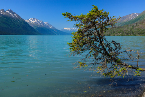
My flight back left Anchorage at 9:30pm on Wednesday the 17th. This gave me the day to drive back and explore more of the Seward Highway and the Kenai Peninsula. My first stop was Kenai Lake. This is one of the largest mountain lakes on the peninsula. It’s a mile wide and 22 miles long with steep mountains that line its shores. This might as well be an inland fjord. I had really only planned to stop at the road in to grab a geocache and move along. But I passed the cache and decided to follow the road to the campground just to see what it was like. When I got to the day use picnic area, I had to get out and see the lake. It was beautiful. The campground was beautiful. If I ever do get to return, this is a place I will spend a night. I was tempted to spend the whole day here, but alas, I had to move on.
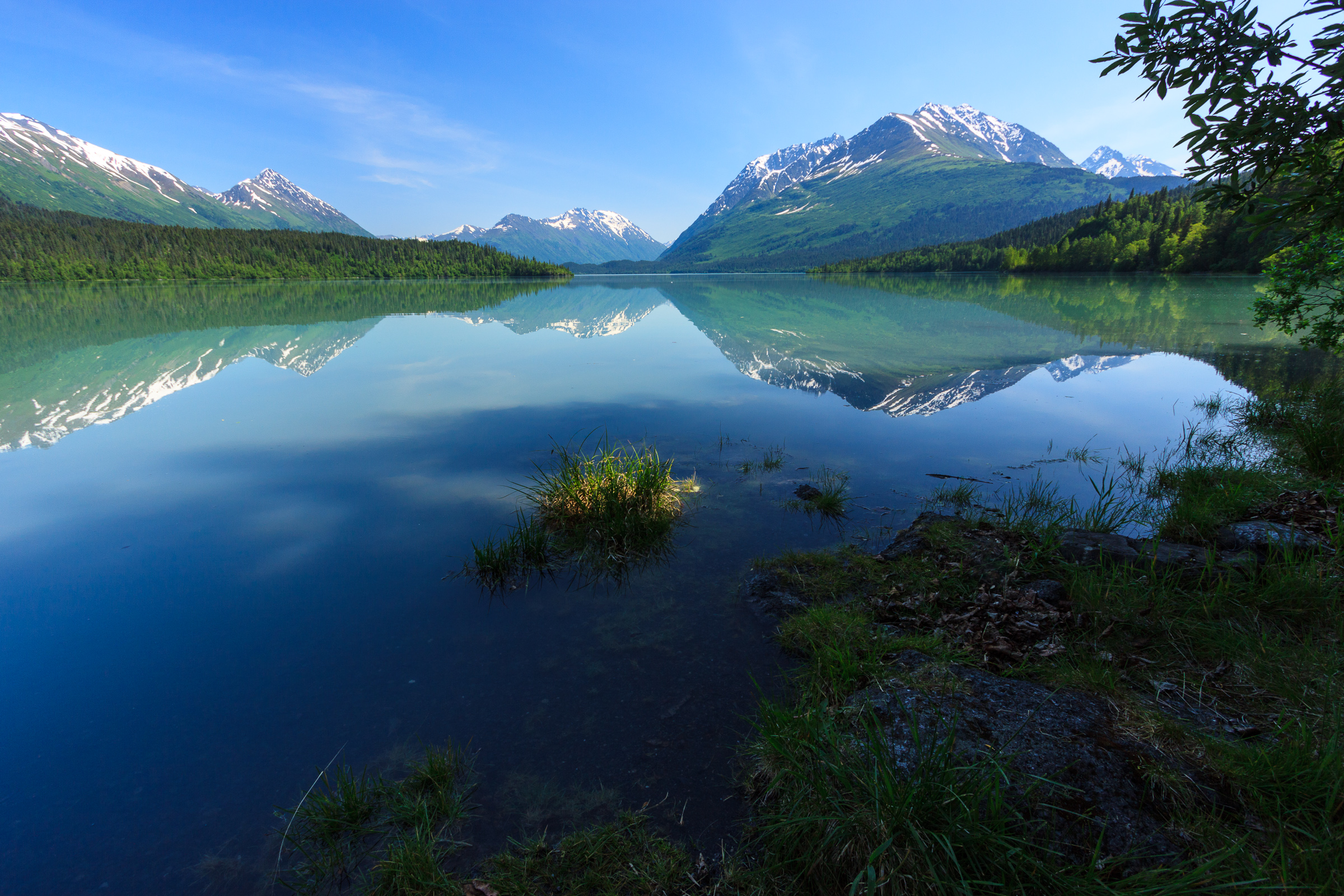
The highway travels along several lakes outside of Seward. The next was Upper and Lower Trail Lakes. I enjoyed the view as I drove by, but made no plans to stop until I noticed the reflections in the water. I immediately turned around and pulled into a little picnic area along the shore of Upper Trail Lake. This is the only lake I came across with a glassy mirror surface. The reflections were perfect and the scene was iconic Alaska. I got my shots, grabbed a geocache that was hidden there, and moved along.

I intended to make one major stop at Portage Lake. This was my place to see a glacier up close – sort of. Portage Glacier still extends to the lake shore, and there were chunks of ice floating in the lake that had calved off of the glacier. But The glacier wasn’t visible from the visitors center and either required a short boat cruise or a hike from Whittier to the other end of the lake. I admit I was unprepared, and had I known the hiking options, I would have driven straight through the tunnel and hiked Portage Pass. Instead, I hiked the Byron Glacier Trail to view a smaller glacier that once would have helped create the lake.
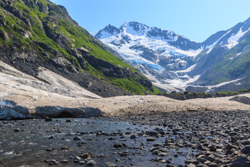
The Byron Glacier trail is an easy .8 miles to the glacier viewing area, and then a more difficult climb over boulders to get to the glacier. I decided not to continue up to the ice and elected to explore some of the area near the lake. Despite not really hiking, I enjoyed my day. I did end up driving through the Whittier Tunnel only to discover that it’s a single lane tube shared with the railroad. Traffic is allowed through one direction at a time, and the direction switches every half-hour. I hadn’t really planned my time efficiently for once I got to Whittier, I almost immediately had to turn around and get in line for the drive back or I’d have to wait another hour and likely miss my flight. I didn’t make any major stops between Portage and Anchorage, since I had stopped along that route on the way down.
Conclusions
Alaska is very neat. It’s huge. There’s a lot to do, and if you only have a few days, it’s hard to decide what to do to maximize your time. It’s also very expensive during the summer, and that’s somewhat of a problem for someone living on a graduate student stipend. It’s also a place that would be a lot more fun to visit without a conference. For example, I would have brought my camping and backpacking gear along if I didn’t also need my computer and conference gear. That may have changed how I spent my time and my funds. I would certainly like to return, but maybe when I’m no longer a student.