Sand Mountain Trail

I don’t get out hiking or geocaching often these days. With geocaching, it makes sense. I’ve found nearly all of the geocaches in a close distance to home and town, forcing me to travel farther distances just to make a find. But when it comes to hiking, I have less of an excuse. I don’t live in Moscow. I live near Deary, 25 miles east, which puts me 25 miles closer to the mountains. It puts me at the edge of the mountains, the foothills if you prefer. There are hiking trails all around. The closest is spud hill, from which there is an amazing view from the top. Then there’s the Potlatch River loop with great opportunities for flora and fauna sightings. There are more trails yet back in the Vassar Meadows area and up near Palouse Divide. I don’t have to go very far to get a nature fix. And yet, what keeps me from going out is more of a psychological barrier than a physical or economic one.

Barrier 1: I’ve hiked the trails before. The excuse is rubbish. But deep down, I desire to explore something new. And so I end up passing an opportunity just to get out because I’m hiking the same trails I’ve hiked in the past.

Barrier 2: The trails aren’t that good, or are shared with motorsports. Again, not a good excuse. Yes, many of the trails in the national forest are designed with single track or ATV use in mind. But that doesn’t mean they are terrible for hiking. The White Pine trail is fantastic, even though many people ride it rather than walk it. And yes, many trails don’t lead to a scenic destination – there are no mountain views, no lakes, no waterfalls. But I also enjoy a walk in the woods for its own merit. Yet sometimes these destinations are what bring me to a trail and I forget to just amble for the sake of ambling.

But once in a while, I’ll discover one of these trails through geocaching, and I’ll be quite impressed. Such is the case with the Sand Mountain trail. This trail traverses the ridge of Sand and Mica Mountains, and recently, someone put a geocache along the Sypah Creek. I knew the this trail existed, but ignored it this whole time because it had never shown up on the list of great hikes in the area. But someone recently placed a geocache along this trail, and so I had to find it.

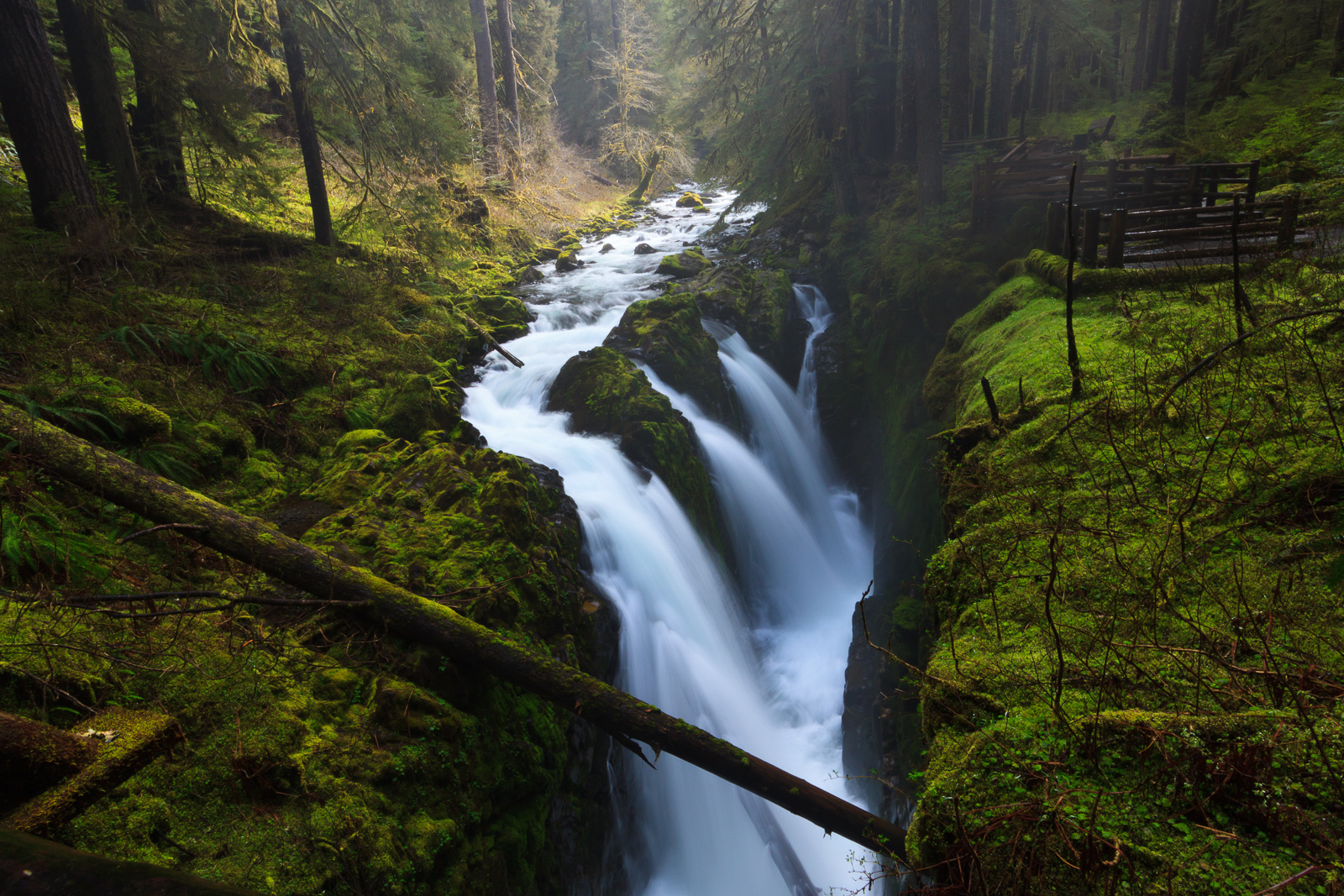
I only hiked a small portion of the trail as it meanders along Sypah Creek for about two and a quarter miles. This section traverses through a lush cedar forest with a carpet of ferns and mosses near the creek. It’s very reminiscent of an inland rainforest, or at least a wet forest. The trail was in good condition, and the climb was gradual – it was 1000 feet up to where I stopped, but I didn’t think we had climbed that high until I looked at the GPS. The trail crosses the creek on a bridge, where we stopped, and then continues up to the ridge and toward the summit of Sand Mountain. I’m not sure if there’s much of a view up there, and I’ll have to return to explore it. But the section I hiked was a beautiful walk in the woods, with a first to find on a geocache as icing on the cake. Watch the video of my hike:

Similar Posts

  • Snowshoeing: Palouse Divide

    I must have forgotten to post about this trip. This was last week, January 5, 2013. This was Idaho Parks and Recreation’s free day in which no parking pass was required to use the Park n’ Ski areas or any of the state parks. There are two Park n’ Ski areas near Moscow: Elk River and Palouse Divide. The Park n’ Ski areas are generally groomed nordic ski trails, but some of them are good for snowshoeing as well. Since the hike to Elk River falls would have been more than 2 miles one-way, I suggested we head up to…

  • |

    Evo-WIBO and the Olympic Peninsula

    I’m two weeks on this post, but forgive me because the last two weeks of the semester have been insane. The bi-annual northwest evolution conference, Evo-WIBO, occurred the last weekend of April. If you don’t remember, I attended the last meeting two years ago and presented a talk on the results of our selection experiment. This year, I presented a poster (my first) on the use of function-value trait analysis to analyze video tracking data. In short, we can use functions to describe behaviors over time and use more details in the data than if we were to simply distill…

  • Grandmother and Grandfather Mountains

    Since my daughter was born a month ago, I haven’t been able to get out and stretch my legs on the trail. So when an opportunity came along to go hiking, I jumped at it. The past few weeks had been miserably hot, even to the point where escaping into the high elevations wouldn’t provide refuge from the heat. However, since nights were cool, the early morning hours were a pleasant time to be outside. So one morning, CJ and I hit up Spud Hill in Deary and made it down just in time for the heat to make life uncomfortable….

  • Big Falls on Overall Run

    Big Falls on Overall Run, originally uploaded by Matthew Singer. It’s great to have my camera back. Two weeks ago, I bent a pin in the card slot which rendered the camera useless. After speaking with Canon support, I packed up the body and shipped it off to the nearest repair facility. It left FedEx that Monday and arrived at Canon on Wednesday. I authorized the repair and it was fixed on Thursday and shipped back on Friday. I received my camera on Friday. While I’m not happy to shell out the expense of fixing my equipment, I am very…

  • Grandmother Mountain

    I finally got some time to get up to Freezeout to hike Grandmother Mountain. The flowers are out and it’s quite pretty, though it’s not the best year for flowers that I’ve seen. It could be that I got up there a little late. Everything seems to be coming out a little earlier this year than normal. But then, all of the flowers that are out still seem to be in peak bloom. I was especially hoping for a great beargrass year like I got to see three years ago. But even with the lower abundance of flowers, the ones…

  • |

    Potlatch River

    Potlatch River, originally uploaded by Matthew Singer. There is a Forest Service hiking trail about 3 miles due north of our house, though it’s about 7 miles to drive there. Still, it’s close for those after-work getaways. The trail is a ~5mi. loop along the Potlatch River that takes you along the river and then up to the “rim” of the canyon. The first half mile or so is paved, but it then becomes a regular old trail through the woods. There are interpretive markers along the entire length. I have been down on the trail several times, but yesterday…