Grandmother Mountain
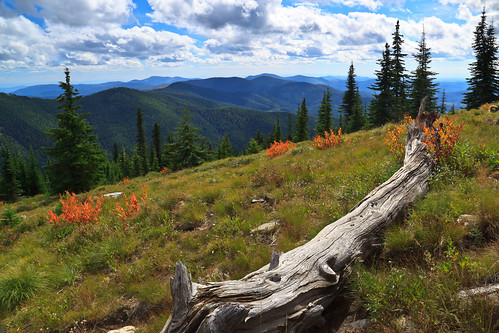
Looking West on Grandmother Mountain, originally uploaded by Matthew Singer.
This weekend, Erin and I set out for our first hike together in Idaho and we made our first summit together on Grandmother Mountain. The hike to Grandmother Mountain begins high up in the St. Joe National Forest 12 miles out of Clarkia. The entire hike is above 5500 feet, which was a neat considering all of our hiking in the East (so far) was under 5500 feet.*
Grandmother Mountain is an easy two-mile one-way along a high sub-alpine ridge with forest mixed with meadow. The summit stands at 6369 feet above sea level and offers a spectacular view over the St. Joe river valley, though the approach to the summit offers spectacular views in all other directions. Add another two miles to get to Grandfather Mountain at 6306 feet. We intended to get to Grandfather Mountain, but got a late start and were slowed down by a sweet surprise along the way. Nevertheless, whether you do the 8-mile or the 4-mile hike, this is a really awesome place to spend a day.
Fall comes early in the high elevations of the northwest. The huckleberry and many other bushes are already displaying their bright colors. But, to our great surprise, the huckleberry bushes still had a plethora of ripe berries to forage upon. The berries up there are small, but pack a punch. Erin likes them better than our blueberries on the Appalachian ridges. On the way back, we stopped in the saddle to enjoy the sunshine and collect about a cup of berries to take home and bake with.
* I’ve hiked above 6000 in New Hampshire and Tennessee/North Carolina, but not with Erin. While Mount Rogers tops out around 5700 ft, we’ve never actually gone to the summit. White Top summit and Thomas Knob/Wilburn Ridge are around 5500ft.