Month: June 2011

  • Upper Basin Trail


    View Upper Basin Trail in a larger map

    The Upper Basin Trail is a 5 mile loop in the upper basin of Elk Creek just north of Elk River The trail is near the giant western red cedar, thought to be the largest tree in the U.S. east of the Sierra-Cascade crest. The loop is also near the Morris Cedar Grove, another grove of large old-growth red cedar. unfortunately, the road to the Morris Grove was closed and blocked off on Saturday.

    If you’re looking for a difficult challenge, the Upper Basin loop is not for you. The trail was built as an interpretative trail with markers along the way. The markers are just numbers and likely correspond to a brochure to carry with you, but there were no brochures to be found at the parking area. The trail itself is quite easy. The total elevation gain is about 400 feet and much of the trail runs along an old railroad grade which is flat and soft.

    Giant Western Red Cedar
    The Giant Red Cedar
    The trail is scenic, but don’t come looking for grand vistas or picturesque stream scenes. Instead, it winds through some of the typical ecosystems in the area: logged forest (regrowth), marshes, meadows, and some more mature forest. I suspect that hiking this trail early in the morning would provide plenty of wildlife sightings. I passed numerous evidence of moose and elk and a few scat piles that may belong to wolf. This is definitely a trail that the whole family could enjoy and it seems to receive little use compared to the Elk River Falls and the Giant Tree, so it’s also a good way to escape the crowds. To get to the trailhead, travel to the town of Elk River, Idaho (Rt. 8 East from Moscow), turn left onto N. Front Street and stay straight on this road. It will eventually turn into a gravel road. At the fork, take the right Fork onto Forest Service Road 382 toward Upper Basin. In about 8 miles, turn Left onto a short spur that leads to the trailhead and parking area.
    GPS coordinates: N46 53.075, W116 09.674
    Clearwater National Forest trail #747

    About 2 miles beyond is the giant Western Red Cedar. This tree is thought to be the largest tree east of the Cascades and Sierras. It measures 18 feet in diameter at breast height and measures 177 feet tall. It is estimated to be about 3000 years old. This short walk through an old-growth cedar grove is short and mostly handicap accessible, though not 100%. There is also a bathroom at the parking area. If you’re in the area, a trip to the tree is worth the visit.

  • Bad Ass Sunset

    Kick-ass Sunset
    Fire in the Sky

    Last night was full of bad-assery. Yeah, that’s right, it was so bad-ass that I made up a word to describe it. After a cold spell, temperatures quickly rose into the 80’s yesterday making for a hot and somewhat muggy day. The conditions were ripe for evening thunderstorms. As I arrived home, I heard reports on the radio that there were some severe storms just west of Orofino. But looking around, all I saw was sunshine and blue skies. The storms were passing to the south of us. As I was washing my car, dark clouds crept in over the field to the south of us, but the skies overhead remained sunny. I heard thunder and the wind was picking up, but still the storms remained to the south. I checked the radar online and saw that Kendrick was getting hit, but we were in the clear for quite some time. I could still see lightning strikes over the horizon.

    But then, everything became much more dramatic. The skies to the south began to glow orange, as if they were on fire. It wasn’t quite time for sunset yet, but then the fire spread to the rest of the sky. This was too good to miss, so I grabbed my camera and set up to shoot the sky with the best available foreground I had. The colors just got more and more intense, I caught glimpse of a rainbow in the distance but it was soon washed out by the glowing clouds. This whole time lightning was still striking in the distance and I thought, how bad-ass would it be if I captured a lightning strike in the midst of an already bad-ass sunset?

    Unfortunately, I wasn’t quite that lucky. My exposures were reading 20 and 30 seconds, long enough for a lightning strike  to occur in the frame by chance, but after each shot, there was an equally long delay from the long exposure noise reduction. Often, this is when the lightning would strike. Just my luck. So when the intense colors faded, I was left with blue clouds over a green field and I decided to keep trying my luck at getting some lightning bolts on frame. Well, the lightning did strike, several times. I thought that lightning was so bright that it would pick up no matter what the exposure settings. I was wrong. After recording a few really nice strikes, I would review the picture only to find no sign of lightning at all. This is a skill I must perfect because when it does storm around here, it’s a pretty spectacular show.

    The storm eventually moved on top of us and by then it would have been dark enough to capture lightning for sure, but I also wasn’t comfortable sitting out there with the camera. At some point during the night, everything had cleared and we had a great view of the stars. By morning, another storm cell had appeared on top of us, spitting down some good-sized chunks of hail. It seems that the storms have finally passed.

    The result: It’s no longer a balmy 85 degrees out there, but a brisk 60. I had to wear a jacket to work today. Nevertheless, last night was bad-ass.

  • Kamiak Butte

    The Palouse, originally uploaded by Matthew Singer.

    The Palouse is made up of rolling hills covered in wheat and barley fields. This area was historically a prairie, so there were few trees to begin with. A few of these hills rise up well above the rest, remnants of a time when the region was more active volcanically.

    Kamiak Butte is one such high point, located less than 10 miles north of Pullman. The north slope is covered by a lush and beautiful forest, protected as a county park for all to enjoy. The park offers a picnic area, a campground, and miles of trails that ascend the butte and follow the ridge to the summit. There are views in all directions including views of both Pullman and Moscow. It’s a great little oasis amidst the sea of farmland. While it’s certainly not wilderness by any stretch of the imagination, it’s a great place to watch wildlife and look for flowers. On yesterday’s walk, I came across a Mountain Lady’s Slipper, but was unable to get a good photograph.

    Kamiak Butte is a good place to get away and enjoy nature. It’s close to Moscow and Pullman and caters to everyone from families to the outdoor enthusiast.

  • Hells Canyon

    This story begins with Luke and I itching to get out into the backcountry. Although it’s the middle of June, the combination of an unusually cold and wet Spring with the very productive winter has left many of the high country destinations (above 5000 ft.) still buried under 100+ inches of snow in places. And even some of the lower areas are still blocked with impassible snow drifts on the road. This makes our options quite limited.

    The one place we’re sure to have access is Hells Canyon. With the river averaging 1200 ft. in between slopes that exceed 7000 feet, Hells Canyon is the deepest canyon in the United States. The Snake River cut a 200-mile ravine through a basalt plateau forming the western border of Idaho with Oregon. At under 1500 feet in elevation, the Snake River itself rarely sees snow and is warm enough for backpacking as early as March and as late as November. However, to get into the canyon, one must either float in from the town of Oxbow, OR or drive along windy roads over the 4500 ft. Pittsburg Saddle and down to Pittsburg Landing. While the road is plowed in the winter, the journey may still be treacherous to the casual traveler.

    It is from Pittsburg Landing that we begin our hike. Our original plan had us hiking 31 miles in 3 days, ascending over 4000 feet out of the canyon from Kirkwood Ranch to Sawpit Saddle, and then returning to the Snake River via Sheep Creek on a trail that hasn’t been maintained in decades. It would have been an ambitious start to the hiking season. But we were unable to take 3 days for this, so we decided to tone it down and just stick to the Idaho Snake River Trail for about 10 miles or so, and hike back out the next day.

    We began our hike huffing and puffing in the heat of mid-day. For a river trail, the Snake River Trail sure covers a lot of elevation gain. At our highest, I think we were 300 feet above the river.

    Kirkwood Ranch is 5.5 miles south from the trail head. It was a working sheep farm back in the day, though as isolated as it is, it must have been tough living. Today, the ranch is a museum and ranger station. There’s also a backcountry campground on the old hayfield, though it offers such cushy amenities as flush toilets. We had planned to stop at Kirkwood for a late lunch break and then keep going, but we found out that the trail had been washed out less than a mile beyond and was rendered impassible. In fact, the “crowd” set up at the campground was mostly a trial crew in for a few weeks to repair the trail.

    We had two options: We could take a detour, which entailed bushwhacking up and over a 2000-foot ridge to get back to the trail and keep going, or camp at Kirkwood and explore the area without packs. As we were already exhausted, the thought of climbing a steep incline with no trail and heavy packs only to be repeated the next day was not appealing. We found a spot, made camp, and went exploring.

    Our destination Saturday evening was up the Kirkwood Trail, an ATV road that eventually led out of the canyon. We weren’t going that far, we headed up about a mile to Carter Mansion, and then up the hill looking for a vantage point. We were told that the views at the top of the ridge were first-rate, but the ascent would take about 3 hours. Tired and exhausted, we opted for a lower goal, a tree atop one of the landings on the way up. We made it within 200 vertical feet of the tree when Matt and I gave up and rested on a rock while Luke made way for the summit. When he returned, Matt decided to make a go for it. And when he returned, I felt as though I had to make my push for the top. So we all individually made it to our goal and then made our way back to camp for dinner.

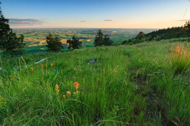
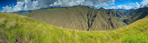
    I slept better than I had in a long while. I think we all did. We awoke refreshed and energetic with our eyes set on another high point just across the field from camp. It was a longer, and steeper climb, but we were rested and ready to go. We made it to the top, what was our top. The ridge kept going up. But from our “summit,” 1300 feet above camp, we had a glorious view over the Snake River. When we woke up and started, the skies were grey and overcast. It had actually rained during the night. But as we climbed that last push for the summit, the clouds broke and the sun came out.

    Bushwhacking up a steep slope is actually the easy part. Coming back down is when there are more chances for injury. We took it slow and careful and eventually made it down to camp in one piece, though we were hurting. We rested, made lunch, refilled water, soaked our feet in the cold stream and packed up camp. Because we had made that climb, we set ourselves up to hike out in the heat of the afternoon, and there was no shortage of heat. The car read 83 degrees when we finally arrived back at the trailhead. The hike back wasn’t nearly as bad as the hike in, but we were still tired from the morning’s climb and it felt good to be back at the car.

    The events that cut our trip short ended up making this a great first trip for the season. The summer temperatures in the canyon will make hiking along the river unbearable for the rest of the season, but we’ll have some chances to explore the high country as the snow melts and roads become accessible. Hells Canyon is a marvel of nature and worth a visit. The scenery is big and awe inspiring, and certainly humbling.


    View Hells Canyon Hike in a larger map

  • Personal Updates

    Lilac Gardens at Manito Park

    It’s been an eventful week, and I should have posted more often, but I’ve been busy and tired and uninspired to write. So I’ll give you the update on the past week, and then some.

    Last Monday was our actual anniversary, and even though we celebrated the week before with a getaway to Oregon, we still wanted to make the day special. We decided to drive up to Spokane, spend some time at REI, and have a nice dinner. For the longest time, I’ve been desiring a GPS unit for the trail, in part because trail maps for Idaho are scarce to none, and in part for the pure geekery that comes with having a GPS. I’ve always wanted to accurately map my route and overlay it on computer maps such as Google Earth, keep track of trip statistics, play with geographical data, and get into geocaching. Erin decided that her anniversary gift to me would be a GPS unit, so with the rather large dividend we earned from last year’s purchases, I got a Garmin Oregon 450t. Suffice to say, for the past week, I’ve been playing with it and having some fun. It’s nice because I can now feed back more detailed trip reports when I come back from a hike.

    While in Spokane, I wanted to have a nice romantic evening at one of the scenic parks. We went to the botanical gardens at Menito Park and walked around for a bit. It was a lovely evening and the gardens were in bloom. We walked through the lilac garden and then through a section of native wildflowers. Unfortunately, we didn’t have much time to walk through all of the gardens, so a return trip is in store. Spokane has surprised me with its awesomeness: a big little city… or a little big city.

    This weekend, we drove out to Elk River with the intent of hiking the North Basin Trail and stopping at the giant tree. To my surprise, the road was blocked with snow, despite being at less than 3000 in elevation. The snow line was definitely higher. I just wasn’t expecting the road to be impassible that low down. So, instead we played closer to town and let the dogs swim in the river. Rusty and Shadow flew in after a stick and floated 100 feet or so through a rapid before coming out. It was cute. We also found a few geocaches near town and then finished the day with a hike to Elk River Falls. It sure is different with the river flowing at full force.

    I will finish with the story of our lawn. Back in April, we bought an old riding mower from someone in Orofino. Despite the age, it was in good working condition with a new engine and everything fixed up. In May, when the lawn had dried out some, I took it for a test and mowed a couple sections of the yard. In that time, the electric starter pooped out, though that’s not a big deal; it has a manual pull start that works just fine. I was able to mow the dry parts of the yard several times, but then a few weeks ago, the lawn mower just stopped working. I was in the middle of cutting the grass when it just shut off on me and I couldn’t get it started. So, unsure what the problem was, I put it in the garage until we could get it fixed. Problem is, we can’t take it anywhere because we don’t have a truck, and we couldn’t find anyone to come out and pick it up. So we decided to just eat the loss and buy a new one.

    In the mean time, the lawn has gone almost a month without having been mowed, and it’s starting to look pretty wild. After doing some research, I went into Sears today and ordered us a new lawn tractor. Then I came home and decided to experiment. I was pretty sure that the engine was fine and I was beginning to suspect something wrong with the electrical system. So I jump-started the lawn mower. To my surprise, it started right up. So I spent the afternoon mowing down the jungle that had taken over the yard. It now looks respectable and once we rake up the clippings, I can go over it with another pass which will smooth everything out. I think I can finally have people over.