Eagle Cap Wilderness, Labor Day Weekend
A year ago this weekend, I set foot in Oregon for the first time and explored one of its most beautiful and least advertised mountain ranges. Last year, we only got a preview of the Eagle Cap Wilderness in the Wallowa Mountains, only able to stay one night. So this year, I arranged the backpacking trip for Labor Day Weekend, which let us spend 3 nights in the wild and explore more of the area. I rarely return to the same place for a second trip as there is so much around to explore, but then, there is the trade-off. Is it better to see a little bit of everything, or thoroughly explore one place?
And so it was, I returned to the Eagle Cap Wilderness with Tyler and we brought Tyler’s fiancee, Genevive, and Tom Poorten, two newcomers to this wilderness. Of course, Rusty and Shadow came as well. Since we couldn’t all fit comfortably into one car, we took two and hiked a shuttled one-way route, hiking up Hurricane Creek to Mirror Lake and heading out down the West Fork of the Wallowa River. This route is a much longer way into the lakes basin than last year’s Lostine River trail, but it’s also the easiest way in, especially when the 12 miles to Mirror Lake are broken up into two days. And that’s just what we did.
Originally, we were to start hiking around 6 or so and hike for about four miles and find camp. But as usual, we were late leaving Moscow and we got into Enterprise at 7. After parking a car at the Wallowa Lake trailhead in Joseph and shuttling over to Hurricane Creek, we got our start on the trail well after dark had fallen. We hiked for an hour, just shy of two miles, before finding a spot in the meadow to make our first camp. Friday night was cold, so cold in fact that we not only had a frost, but I woke up with ice in my water bottle. Temperatures remained near freezing through the morning until the sun had risen high enough to hit the valley floor. We ended up waiting long enough to let the sun warm us up and dry the tents before heading up the valley.
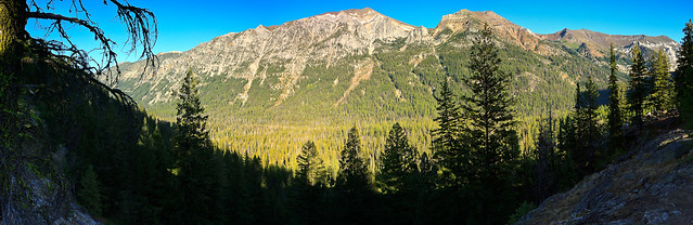
The Hurricane Creek valley is magnificent. The entire trip is a gentle upward slope, rising about 2000 feet over 10 miles while surrounded by giant peaks rising upwards of 4000 feet into the sky. We woke up with a grand view of Sacajawea, the highest peak in the range. I must say it looks quite different without snow covering its rocky summit. After passing the giant mountain, we’re introduced to the white cliffs of Matterhorn, which due to its more vertical nature, looks even more impressive. The terrain is a mix of open meadow and forest, but nothing nearly as wide open as the upper Lostine River valley. Still, the diversity of terrain and scenery makes this trail almost more scenic than any of the other approaches. After hiking 10 miles in the valley, the trail climbs up one of the back walls via a series of gentle switchbacks and descends into the Lakes Basin area. The summit of Eagle Cap becomes visible and excitement washes over with the prospects of finally getting to the lake. Though the trail was relatively easy, we were quite bushed from hiking 10 miles uphill and quite glad to set up camp on the rocks with a great view of Eagle Cap and Mirror Lake.
Saturday night was much warmer, as expected. In the fall, mountains experience a temperature inversion from day to night where the cool temperatures fall into the deep vallies and the warm temperatures rise to the high elevations. As a result, we had a very pleasant night by Mirror Lake. In fact, after eating dinner and packing away the food, we sat out on the rocks looking at the stars.
We spent a relaxed Sunday morning enjoying the area around Mirror Lake. Originally, we had tenative plans to hike up to the summit of Eagle Cap, return and pack up camp and move about 3-4 miles down to Horseshoe Lake and hike out the last 9 miles on Monday. However, we were still tired from our 10 miles of hiking on Saturday, so we decided that a summit of Eagle Cap would have to happen on another trip. Then, pressed with the option of camping at Horseshoe Lake or continuing on into the Valley for a shorter hike out on Monday, we decided it would make more sense for the latter option so that we weren’t getting home super late. Regardless, we left our camp at Mirror Lake around noon and headed down along the lakes, taking short breaks at Moccasin, Douglas, Lee Lakes. We stopped for a long lunch at Horseshoe Lake and found a great jumping rock to plunge into the cold water. Surprisingly, Horseshoe Lake wasn’t too cold and the swim was quite refreshing for a hot day.
Mirror Lake is definitely the desired destination in the Eagle Cap Wilderness. It’s one of the higher lakes, is centrally located, and sets you up for a nice summit trip to Eagle Cap. But Mirror Lake is also quite popular, and the prime campsites near the water are almost always taken quite early. Despite the popularity, it is easy to find a place that is somewhat secluded and gives the impression that you’re not camping among a crowd. But the other lakes have their advantages too. They are quieter, they have more trees around them, they’re better for fishing, and they have some really awesome campsites. You can be certain to have privacy at these lakes, and still have world class views of the high peaks. The peninsula on Horseshoe Lake offers spectacular views of Pete’s Point and Sentinel Mountain, and from certain angles, you can also glimpse Eagle Cap. Horseshoe is still at 7000 feet, but as the last lake in the chain, it is warmer and more eutrified than the lakes uphill from it. In fact, there are a few nice marshy areas along the trail that look like great amphibian habitat. The water is still clear, and the lake is still deep. But there are likely to be more fish in there than at Mirror Lake.
After Horseshoe Lake, the trail drops into the valley of the West Fork Wallowa River. This descent, while not strenuous, is about 3 miles that would be a steeper incline in the other direction than any incline on the Hurricane Creek Trail. I’m certainly glad we chose the direction that we did. Shortly after the descent began, we came upon a rocky shelf looking over the valley. Convinced there was a view to be had, I dropped my pack and ran out to the rocks. Sure enough, there was a magnificent view of the back valley. The Wallowa River valley is a classic glacially-carved U-shaped valley about 3000 feet deep and maybe a mile wide at the base. The views we got from this rock were like those you’d get at a national park. It was glorious. The trail opens up again a few more times on the way down before reaching the valley floor at Six Mile Meadow. There is good camping at the meadow, six miles from the trailhead, but it proved to be a popular site, so we pressed on to see if we could find anything else nearby. Turns out, much of the Wallowa River valley is forested, unlike Hurricane Creek, and camp sites are few and far between. We ended up camping three miles farther at the intersection with the Ice Lake trail. This put us at a second 10-mile day, but would afford us the luxury of sleeping in a bit and only hiking out about 3 miles on Monday.
Sunday night was colder than Saturday night at the lake, but not as cold as Friday with the frost. We built a fire in the fire pit and sat around to keep warm during dinner. The morning was also cold, but not nearly as bitter as our first morning, so we were able to get moving fairly early. We ended up leaving camp around 9 and getting to the car well before noon. We celebrated with a post-hike beer and lunch at the Terminal Gravity Brew Pub in Enterprise, a well deserved treat after two back-to-back 10-mile days of hiking and three nights in the wilderness. Although I was sad to leave such a beautiful landscape, I was glad to be back in the comfort of my bed, take a break from hiking, and have a hot shower.
The Eagle Cap Wilderness is one of the most beautiful and special places I have been to, and that’s one of the reasons I keep returning. This will certainly not be my last visit or backpacking trip in the Wallowas as there are so many more places within these mountains to see and explore. I hope we can keep up this tradition and next year, I’ll get to report on the third annual Eagle Cap Wilderness backpacking adventure.