Palouse Falls

There seems to be a trend among people that when you live in a certain area, you tend to take for granted your proximity to tourist attractions and not visit them. Local attractions aren’t really a priority because they’re always there, so you can always visit them later. Well, later can turn into years. In this case, three years. I’ve gone three years without having visited Palouse Falls despite it being a major attraction in the area. To be fair, Palouse Falls isn’t really on the Palouse, but it’s an almost 200 foot sheer drop along the Palouse River in central Washington. It takes about two hours to get there from Moscow, and there’s not a whole lot else around it. Thus, it hadn’t been high on my priorities. Nevertheless, I’ve always wanted to see the falls, and I made an excuse to take Erin to go see them this weekend. To make the drive worth the effort, I planned to grab as many geocaches along the way as I could. I think I did pretty well: thirteen in one day.

So, here’s what makes Palouse Falls so special:
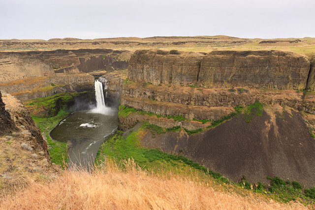
Palouse Falls - farther back

That waterfall is nearly 200 feet tall, 198 feet to be precise. If that’s not impressive enough, the falls are less than half the total depth of the canyon. Needless to say, this basalt gorge is pretty neat. The sheer canyon cliffs remind me of the sandstone canyons of southern Utah, at least in shape. It’s a very cliche western scenery. Somehow, there are trails that lead closer to the falls and even to the bottom, but with my leg still healing, I wasn’t about to risk an injury. So, we stayed in the safety of the canyon rim.

When I said that Palouse Falls was not on the Palouse, what I meant was that it’s not in the eco-region called the Palouse. The Palouse was a prairie, much of which has been raised for agriculture. It’s a region of lush rolling hills, wheat, canola, and lentil farms, and general awesomeness that looks much like this:
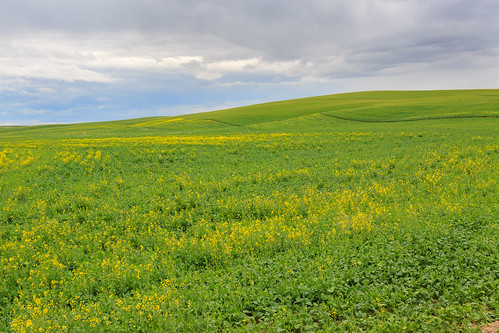
The Palouse

In contrast, there’s a point heading west where the farms end and the scrubby rangeland begins. It’s almost a desert out there with the main flora consisting of sagebrush and fewer grasses. It reminds me of southern Idaho, which is also a sagebrush steppe semi-desert with canyons cutting through the bassalt. I suppose that’s the real attraction. The landscape is beautiful. The towns are not. The nearest town to the falls is Washtucna. There’s a convenience store and a country dive bar. The rest of town is boarded up.

Despite its proximity to almost nothing, the park at the falls is pretty nice. There’s a well-kept lawn for picnics and camping and the trails are well maintained and easy to follow. I thought that the rainy weather would hamper my photography expedition, but I think I got a few nice shots with the wet camera. I’d certainly like to return in better weather, maybe even camp out to get some sunset and sunrise shots at the falls. I’d certainly like to hike down into the canyon once my leg gets better.
Palouse Falls Canyon View

Similar Posts

  • |

    Potlatch River

    Potlatch River, originally uploaded by Matthew Singer. There is a Forest Service hiking trail about 3 miles due north of our house, though it’s about 7 miles to drive there. Still, it’s close for those after-work getaways. The trail is a ~5mi. loop along the Potlatch River that takes you along the river and then up to the “rim” of the canyon. The first half mile or so is paved, but it then becomes a regular old trail through the woods. There are interpretive markers along the entire length. I have been down on the trail several times, but yesterday…

  • Grandmother Mountain

    Looking West on Grandmother Mountain, originally uploaded by Matthew Singer. This weekend, Erin and I set out for our first hike together in Idaho and we made our first summit together on Grandmother Mountain. The hike to Grandmother Mountain begins high up in the St. Joe National Forest 12 miles out of Clarkia. The entire hike is above 5500 feet, which was a neat considering all of our hiking in the East (so far) was under 5500 feet.* Grandmother Mountain is an easy two-mile one-way along a high sub-alpine ridge with forest mixed with meadow. The summit stands at 6369…

  • Grandmother and Grandfather Mountains

    Since my daughter was born a month ago, I haven’t been able to get out and stretch my legs on the trail. So when an opportunity came along to go hiking, I jumped at it. The past few weeks had been miserably hot, even to the point where escaping into the high elevations wouldn’t provide refuge from the heat. However, since nights were cool, the early morning hours were a pleasant time to be outside. So one morning, CJ and I hit up Spud Hill in Deary and made it down just in time for the heat to make life uncomfortable….

  • |

    Fourth of July

    For many years, I have spent my Fourth of July basking in the part of America that I enjoy the most: its wild and natural beauty. It started in 2011 when I explored the Hobo Cedar Grove for the first time. Then again in 2013 when I hiked Grandmother Mountain. In 2015, I spent the fourth in the Seven Devils with friends. This year, I returned to Grandmother Mountain for what may be my last visit to one of my favorite peaks in the vicinity of Moscow.

  • Winter Hike to Jerry Johnson Hot Springs

    Last weekend, I reported on a snowshoe hike along the Potlatch River and alluded to a second snowshoe adventure the same weekend. In fact, we had planned a little excursion out along Rt. 12 to Jerry Johnson hot springs. It turned out that the hot springs are still popular in winter, at least enough so that the one-mile trail was packed down such that we didn’t need snowshoes after all. So, for the second time this season, a snowshoe hike simply became a winter hike. While we were all looking forward to snowshoeing in, the real goal was to soak…

  • Asotin Creek

    It’s funny that only two weeks ago, I was clearing snow from my driveway, and now there’s hardly any sign of winter left on the Palouse. Instead of snow, it rained for nearly a week straight. So when we caught a break in the weather on Saturday, I was quite happy to take advantage and begin my spring hiking season. I chose to go to Asotin Creek. The town of Asotin is located five miles south of Clarkston, Washington. It is here that Asotin Creek empties its water into the Snake River. But the hiking begins about 20 miles upstream…