4th of July
The celebration of our nation’s independence is a custom dating back all the way to the day the Continental Congress approved and signed the Declaration of Independence. The use of fireworks to celebrate the momentous and historic occasion also dates back to that time. As John Adams wrote to his wife:
“The second day of July, 1776, will be the most memorable epoch in the history of America. I am apt to believe that it will be celebrated by succeeding generations as the great anniversary festival. It ought to be commemorated as the day of deliverance, by solemn acts of devotion to God Almighty. It ought to be solemnized with pomp and parade, with shows, games, sports, guns, bells, bonfires, and illuminations, from one end of this continent to the other, from this time forward forever more.”
Adams’ reference to the second of July marks the day that the Continental Congress approved a measure to declare independence. The official document, was signed two days later. Regardless, the founding fathers had visions that for years to come, that day would be memorialized with great celebration including the beloved fireworks display we have come to enjoy.
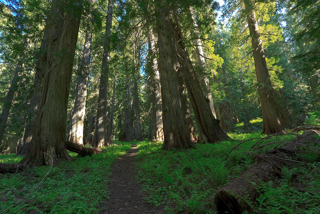
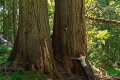
But while most people were celebrating America by blowing a part of it up, I chose a much more solemn way to pay tribute to this great country. We often remember our historical heritage during these days, but we sometimes forget about our natural heritage. On this day, I visited a grove of trees so old, they were standing tall long before the European settlers ever set foot upon the continent. These trees are a testament to the persistence of nature to thrive against the rugged challenges thrown at it. These trees have survived centuries of fire, drought, snow, and winds. And after all of the beatings, the trees still stand only to be taken down in mere hours by the hand of man.
 There are few old-growth virgin timber stands left in the United States. When the settlers arrived, they quickly chopped down the forests for farm land, wood, and security. After all, much of Europe’s forests had already been decimated before the Americas were colonized, and the wilderness was a scary and dangerous place. But it also provided raw materials and natural resources with which to create new products and amass wealth. When the West was finally settled, the forests, with their big trees, were quickly taken advantage of. Fortunately, a few of the industrialists and businessmen who were responsible for the massive destruction of the landscape also recognized the importance of preserving some of it for generations to come. And for whatever reason, whether it be inaccessibility or the sheer awe struck by the people who saw them, some of these stands of forest were spared the wrath of the timber and mining industries and preserved for us to see today.
My 4th of July trip took me to the Hobo Cedar Grove and Botanical Area near the town of Clarkia, Idaho. The trees here aren’t the largest, but the forest is impressive. The one-mile walk through this patch of old-growth forest is enough to make you forget that you drove through a clear-cut to get there. At 4500 feet, it’s a great place to beat the heat. Temperatures on the Palouse were over 80 at mid-day, yet when I pulled into the parking area, the air was a pleasant 72. There is a picnic area and restroom at the trailhead, and a one-mile loop through some of the most beautiful forest I have ever seen. There is a shorter interpretive nature trail as well. The trail is well-maintained, though there were several downed trees across the path at this time. I suspect the maintenance occurs later in the summer. The drive to the grove is very scenic as well. From Clarkia, you drive along Merry Creek and then ascend into the mountains. While you do drive through a section of clear-cut forest, the clear-cut does open up views of the mountains to the west.
There are lots of other things to do in the area as well. You can continue driving to the St. Joe River, or take another turn back in Clarkia and head up to Freezeout Saddle. As of a few weeks ago, the road was drivable almost to the Grandfather Mountain trailhead. I imagine that if the road isn’t clear now, it will be in a week or two. Back down in Clarkia, you can search for fossils at the Fossil Bowl or head to the Emerald Creek Garnet Area, one of only two places in the world where you can find star garnets.
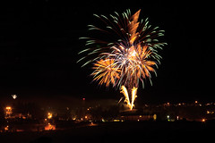
I am thankful that somebody had the foresight to preserve and protect the awesome beauty and splendor of our natural heritage, leaving us with great places for recreation and study. Oh, and in case you were wondering, yes, I did partake in the explosive celebrations later in the evening.