Canoeing the St. Joe
Hello.
I realize it’s been quite some time since my last post. That’s what happens when you get into dissertation writing mode. Life tends to cease and all you can think about is finishing this damn thesis. As a result, I haven’t really been on many adventures since December, nor has there been anything interesting to write about, nor have I had time to really write about anything, so I’m taking a short break to write about my most recent adventure.
It’s Spring Break at the University of Idaho, and while some students are headed south for warmer weather, others headed into the mountains for some end of season snow. Meanwhile, a small group of us headed out to the St. Joe River to canoe 34 miles in the cold and rain. Our adventure begins at the Huckleberry Campground, about 12 river miles downstream of Avery. We pulled in Friday night after dining and drinking with the locals in St. Maries. We parked a car in town and took two more with us to the campground, one a giant van with two boats on top, the other my Forester with the third boat. We slept in the cars to avoid packing up wet tents, though we brought an extra tent to help with space. Though it rained through the night, we were lucky to wake up to a (relatively) dry morning.
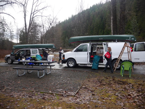

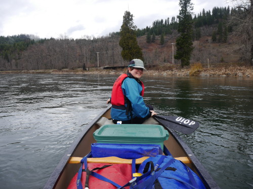
Photo by Thibault Stalder
I feel that we were quite lucky on this trip. The weather forecast originally called for rain all day on Saturday, but when we pushed off, there wasn’t a drop from the sky. We even saw some blue overhead during the morning. The water was flowing fast, and we started off pushing almost eight miles an hour, but that pace didn’t last long. It took us about an hour to reach Caulder six miles down the river. We managed to keep up that pace for the next seven miles where we pulled off for lunch. After that, things slowed down. The river deepens and slows to a near halt as the water level approaches that of Lake Coeur d’Alene where the river empties many miles past St. Maries. The last few miles of the day were spent paddling flat water. Despite some gusts of wind nearly blowing us backward, we made eight and a half miles in two hours. In total, we paddled 21.8 miles in four hours, not including the hour and a half lunch break.
As mentioned earlier, we had great weather during the first half of the day. But while we were stopped for lunch, we were hit with a short rain shower. Luckily it blew past and we headed back on the river with hopes for a dry trip. But it didn’t last long. We had hit the flat water and were about three miles from camp when the storm hit for good. I’m thankful that my rain pants were still waterproof after all these years. My rain jacket was still doing ok, but started to get damp on the inside. I suppose even Gore-tex doesn’t last forever. We stopped for the night at the Shadowy St. Joe campground, which was technically closed for the season, but the Forest Service told us that nobody would kick us out.
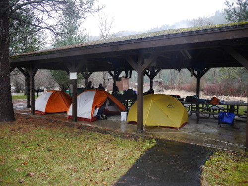
Because of the rainy forecast, we had packed tarps to hang at the campground so we could set up our tents without getting them wet on the inside. We were quite relieved to find a large picnic shelter at the campground. There was ample room to unpack our bags and set up our tents. In the end, we slept under the shelter. Wesley and Thibault then hitched a ride to our starting point to bring the cars closer, reducing the shuttle time when we finished. It was also to retrieve some items left in the car that we needed for dinner. The rain did let up around 5:00 and we were able to build a fire in the fire pit to cook burgers. But for a while, we were looking at the possibility of a cold and wet evening. In the morning, we awoke to clear blue skies and sunshine, which is what we expected from the weather forecast. That gave us a bit of warmth and optimism for the day’s trek.
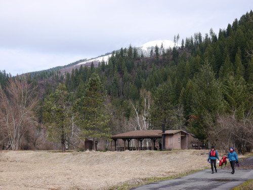
Since we had the cars parked outside the campground, we were able to leave most of our gear behind which made packing up and preparing the canoes a little easier. We pushed off and paddled 12.8 miles of flat water to the town of St. Maries. St. Joe Baldy rose above the river showing off its bright white summit. There seemed to be enough snow to ski up there. Unlike Saturday’s fast pace, we averaged a little under four miles an hour and completed the entire stretch in three and a half hours. Again, the rain returned as we were only a few miles away from our take-out, but it was enough to soak us. On such a rainy day, there weren’t many people out at the river park in town, so we left the canoes and warmed up in a nearby coffee shop. The rain stopped as we headed out to retrieve the other cars, but we sure timed our departure quite well. As I was leaving St. Maries, I drove into the middle of an intense thunder and hail storm. I was not expecting that this time of year.
In total, we paddled 34 miles in 8 hours, excluding breaks. I would never have thought to plan a canoe trip in March, but it worked and we had a great time. In the map above, day 1 is shown in pink and day 2 in purple.