|

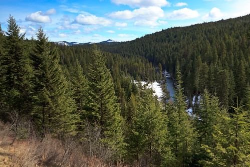
Potlatch River


Potlatch River, originally uploaded by Matthew Singer.

There is a Forest Service hiking trail about 3 miles due north of our house, though it’s about 7 miles to drive there. Still, it’s close for those after-work getaways. The trail is a ~5mi. loop along the Potlatch River that takes you along the river and then up to the “rim” of the canyon. The first half mile or so is paved, but it then becomes a regular old trail through the woods. There are interpretive markers along the entire length.

I have been down on the trail several times, but yesterday was the first time I decided to do the entire loop. It turns out that while we have no snow left at the house, there is still plenty on the ground out there and what should have taken 2 hours to complete ended up taking a good chunk of my day (and energy!). I actually hiked the loop backward going up to the top first and coming back along the river. Had I gone the other direction, I may not have hiked the loop at all. The snow along the river was still 2+ feet deep and not packed down very well. Every other step or so, I’d sink down to my knees, and the dogs weren’t having an easier time.

Still, despite the difficulty with the snow, this trail seems promising. It traverses through a diversity of habitats and promises to offer good wildlife. I came across the scat of deer, elk, and moose, but did not see any. It could be the combination of my timing (mid-day) and the fact that I had the dogs with me. I saw and heard tons of birds, but without binoculars, I couldn’t identify all of them. I heard Pileated woodpeckers and came across another unidentified woodpecker. There were chickadees galore, and a wren that flew across the trail. We spooked several grouse and saw a turkey in the big meadow by the river. And on the river, I caught a pair of Common merganser.

The trail takes you through a variety of habitats including new forest, thinned/open forest, mature forest, river, meadow, upland, lowland. The best surprise was a clearing with a scenic overlook on top of the canyon (pictured above). The view looks down upon the river, across a swatch of forest and out to some higher peaks off in the distance. Despite being so close to farm and logging lands, the trail feels like it’s secluded in its own patch of wilderness.

I think when the snow melts, the trail will be a bit more fun to explore and revisit. It’s nice to have something like this so close to home.
Similar Posts

  • Upper Basin Trail

    View Upper Basin Trail in a larger map The Upper Basin Trail is a 5 mile loop in the upper basin of Elk Creek just north of Elk River The trail is near the giant western red cedar, thought to be the largest tree in the U.S. east of the Sierra-Cascade crest. The loop is also near the Morris Cedar Grove, another grove of large old-growth red cedar. unfortunately, the road to the Morris Grove was closed and blocked off on Saturday. If you’re looking for a difficult challenge, the Upper Basin loop is not for you. The trail was…

  • |

    Aurora

    We got alerts that a solar flare could cause an aurora that would be visible into the middle states. So, last night, I checked the sky and luckily it was clear to the north. I saw a faint glow on the horizon and set up the camera. Sure enough, there was an aurora. The excitement didn’t last too long. I wanted to view this one from Steptoe Butte, one of the best places around for viewing auroral activity. So, we got in the car and started driving west. Unfortunately, the sky was overcast over much of the Palouse, and by…

  • Elk Butte

    Ever since I first visited Elk River during my interview trip in February 2010, I had a desire to get to the top of Elk Butte. After all, who could resist a lookout tower boasting 3000 foot views? The only problem was finding a suitable way to get up there. While the maps show a road to the summit, descriptions also warn that the summit is not accessible by car. Most people reach the summit by four-wheelers in the summer and snowmobiles in the winter. I had read that it was a 7-mile one-way trip, which ruled out a day…

  • Seven Devils on the Fourth of July

    What do you do when temperatures rise above 100º F? Seek relief at very high elevations. This June was one of the hottest on record for the northwest with several days above 100 degrees in Moscow. So when my friends proposed a backpacking trip for the Fourth of July weekend, i was a bit skeptical, especially given the location’s tendency to get hot and dry in the summer months. It’s also a very popular destination for holiday weekends, though it’s not usually accessible for the Fourth of July. So it could have been really crowded, or completely empty. They wanted…

  • Asotin Creek

    It’s funny that only two weeks ago, I was clearing snow from my driveway, and now there’s hardly any sign of winter left on the Palouse. Instead of snow, it rained for nearly a week straight. So when we caught a break in the weather on Saturday, I was quite happy to take advantage and begin my spring hiking season. I chose to go to Asotin Creek. The town of Asotin is located five miles south of Clarkston, Washington. It is here that Asotin Creek empties its water into the Snake River. But the hiking begins about 20 miles upstream…

  • |

    Fourth of July

    For many years, I have spent my Fourth of July basking in the part of America that I enjoy the most: its wild and natural beauty. It started in 2011 when I explored the Hobo Cedar Grove for the first time. Then again in 2013 when I hiked Grandmother Mountain. In 2015, I spent the fourth in the Seven Devils with friends. This year, I returned to Grandmother Mountain for what may be my last visit to one of my favorite peaks in the vicinity of Moscow.